EDITORS NOTE: This post was originally written last December, we are republishing it because there was shitstorm after The Glitter Ginger’s post this morning.
This real talk might cause a bit of a stir, but that’s why it’s called real talk. Someone needs to say this. We should switch what is called the “Upper Cape” and the “Lower Cape”. It makes no sense whatsoever. The “Upper Cape” has a lower latitude coordinate than the “Lower Cape”. Game, set, match.
By most accounts the upper, lower thing is left over from nautical terms and the fact that traveling down wind would generally take you in a south westerly direction. Another theory is that the train stations were listed with the furthest towns at the top. Leading to a sense of going “down” when traveling from P-Town to Bourne. Well that’s just stupid. We’ve had cars and roads for over a hundred years now, it’s time to let go of the past.
Residents here get a kick out of tourists getting confused by what is the “Upper Cape” and what is the “Lower Cape”, but be honest with yourself, you would get it wrong the first time too. If New York called the southern part of their state “Upstate” and the northern part “Downstate” we would crucify them for it. It would make no sense.
Look I’m all for history, unless it’s stupid. Fenway Park is a lovely historic park but it still sucks to sit in chairs that were designed when the average person was 5′ 4″ and 138 pounds. If you think objectively and rationally about what the Upper Cape should be and you picture Woods Hole then you are deranged.
So I propose we fix this crap and bring ourselves into the 21st century. What would it really take anyway? Rename a couple of High Schools and Lumber Yards and call it a day. There is just no reason that in this modern and civilized society, that Harwich and Chatham should be “lower” than Falmouth and Mashpee.
P.S. ANYONE that brings the arm argument up should be stoned in the town square, this is grown folk talk, go sit at the kids table.
P.P.S. Please send all maniacal 500 word and above diatribe emails to insanetony@therealcape.com
Facebook: The Real CapeTwitter: Hippie - Insane Tony
More Articles From The Real Cape:




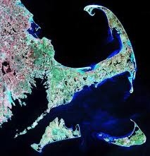

The only viable argument I’ve heard is that it has to do with Rt 28. North is in Boston and South is in Orleans. So that puts Orleans at the bottom. I’m not saying its still not confusing but that’s the only thing I’ve heard that makes a modicum of sense.
I always understood it that since people go “down to the cape” once you cross the bridge you are at the top of it and continue your way down to ptown.
It has to do with elevation
the same thing goes on on the Vineyard – “up-island and down-island”. And my understanding is that it’s not about latitude, but longitude. I’m still OK with it. Also, I’m from Bourne, and it’s the only chance we have to be on top of anything besides worst traffic.
You mean to tell me Bourne has a lower latitude than Chatham? Falmouth isn’t the only town thats upper cape bro. Matty Bizzle hit the nail on the head. Down the cape.
Most of it does yes, and Chatham isn’t the only town that’s lower cape bro http://pubs.usgs.gov/of/2003/of03-221/data/basemaps/cape_cod_geology/capecodgeology.gif
Its’ kinda like going ‘Down East’…….
No, it’s Longitude, the east/west measurement. Lower Cape has a lower Longitude (Greenwich, England is 0), Upper cape has a higher longitude, being ever so slightly farther west from England.
Seconded, nice to see someone else knows their navigation.
The prevailing wind is out of the southwest, so that would have you sailing “down wind”