
Cape Cod Commission
Transportation Committee
P.O. Box 226
3225 Main Street
Barnstable, MA 02630
Dear Commissioners,
I propose that the Cape Cod Commission’s long-term transportation plan for southeastern Massachusetts and Cape Cod include a new, modern bridge over the Cape Cod Canal. This idea was previously forwarded by me to the Governor in 1997 by, as well as to the Cape Cod Times Editorial board. Today the Bourne and Sagamore Bridges are seventy years old, and if any real expectation to replace them is undertaken, or a federal project is started, it would likely take more than ten years to become a reality.
The residents of Cape Cod cannot wait that long for the project to begin. We need a new bridge that should be constructed so as to accommodate long-term maintenance projects without causing a bridge closure. The rail bridge is a problem too, but engineering design can increase the life and utility of that bridge.
I appreciate that public sentiment for old fixtures like the bridges is strong, and I also know that there is preponderance by many residents that bridge traffic helps to reduce further growth. I have heard this for years, and yet still witness growing traffic congestion. The real issue is that metal is subject to fatigue, and even the best built bridge eventually will fail. In addition, issues such as modern highway construction, emergency egress during natural disasters, and less reliance on fossil fuels by motorists should dominate the planning, not sentiment or ill conceived ideas of planned growth and traffic management.
Each day as I travel over the Bourne Bridge I am amazed that more traffic accidents don’t occur. The lanes are narrow and no breakdown lanes exist. I think back to the early eighties when we had to endure months of only one bridge when the bridges were undergoing life extension projects. I recall miles and miles of snarled traffic when one lane in each direction was suspended to replace the road surface just a few years ago. I can’t even imagine the turmoil when the next long-term bridge closure occurs.
Bridge Approaches: At present we still have the ability to utilize some state and federal land to accommodate a new bridge. The new could be built approximately midway between the two bridges that exist today, just south of the high-tension transmissions lines crossing the Canal in Bournedale. As eastbound Route 25 turns from east to south in Bournedale (skirting the Ingersoll family horse farm) the new bridge would be less than one mile away, and after crossing the Canal and the Old King’s Highway, the merge point with Mid Cape Highway Route 6 would also be about a mile.
The Bridge: The new Cape Cod Canal Bridge should be a duplication of the bridge built over the Connecticut River in Old Saybrook, Connecticut that was built in the late eighties. The bridge provides four lanes in each direction, as well as two break-down lanes in each direction, giving the bridge a 12 lane width. Such design would permit off-season paving and repair without interfering with the primary function of the bridge. The location over the Canal is also in an area of high landmass on each side of the Canal, thereby reducing the expense of a highway elevating approach.
Bridge Connections: The baseline description above creates a direct connection between state road Route 25 with federal highway Route 6, that serves the mid-Cape and lower Cape. The issues that the two other highways can be served the connections are equally important. On the Plymouth side of the Canal, Route 3 could connect with the western bridge approach via a connector out of the new north side interchange, the so-called flyover. Or, and more useful, a new highway could be built that follows the Plymouth-Bourne border, over Herring Pond Road and over Bournedale Road to an entry onto the spur off of Route 25 that would approach the new bridge. On the Cape side, Route 28 that serves the Bourne and Falmouth areas can be connected with the new bridge east of the Bourne Landfill, and into Macarthur Boulevard, on federal property.
Discussion:
– Road Traffic: This new plan would immediately remove any further discussion of a flyover project near the Bourne Bridge Rotary on the east side of the Bourne Bridge, as well as the traffic issues surrounding development of land near the rotary. The new idea would totally remove all concerns about traffic congestion in Sandwich. Unfortunately, this plan does render the new Sagamore Bridge flyover obsolete almost immediately, but it will have served its purpose well for perhaps ten years before the new milestone.
– Commerce: In keeping with my marine transportation roots, this new bridge will permit the removal of the two old bridges built in 1935 that have served so well, and allow for a greater “air draft” for transiting ships. This will permit the new generation of passenger ships and larger containerships to use the passage.
– Environment: The prospect of taller ships would also rationalize the Army Corps to proceed with dredging the Canal to the design depth of 40 feet, thus allowing for greater under keel clearance of ships, allowing for a larger margin of error in avoiding groundings and the resultant pollution from ships. Also, the greater use of the Canal will reduce the number of ships transiting the Stelwagan Bank Marine Sanctuary, and therefore reducing the probability of the ship strikes on the endangered Right Whale
– Tourism: Believe it or not, ships in passage through the Canal can contribute to tourism, as they glide through so effortlessly. But more importantly, creating a more efficient access to the Cape will promote tourism for the Cape as a whole.
Many years ago I participated in a research project on the Commonwealth of Massachusetts’ marine transportation infrastructure for the Governor’s Commission on Port Development. The document became part of a report that lead to a $300 million bond bill that continues to provide public funds for dredging and port infrastructure as approved by the Governor’s Seaport Advisory Council. During that period, and since, I have watched with interest the planning and action in regional transportation issues. When I recently read about the long-term Cape Cod Commission Transportation Plan, I feel I am obligated to make this recommendation.
My work at Massachusetts Maritime Academy keeps me quite busy. Sadly, this keeps my community service more federal than local, as I serve on two national committees dedicated to marine transportation safety and operational issues. I also am a board member of the Boston Marine Society which is keenly involved in ship’s pilot’s activities in Massachusetts, and I serve as the Cape and Island Representative for the Seaport Advisory Counsel.
I write this letter as a concerned Falmouth resident, and hope that there is no suggestion that this is the opinion of Massachusetts Maritime Academy If the members of the transportation committee have any questions, I am available at 508-830-5020, or via email at <[email protected]>.
Sincerely,
Thomas L. Bushy
Vice President of Marine Operations
Massachusetts Maritime Academy
Enclosure (1) Small scale image of Southeastern Massachusetts and the Upper Cape Cod Region
CC:
Governor Deval Patrick
RADM Richard Gurnon, President, Massachusetts Maritime Academy
Captain John Gibbons, District Three Pilot Commissioner
Cape Cod Times Editorial Board
Falmouth Enterprise Editorial Board
ENCLOSURE (1)
Small scale image of Southeastern Massachusetts and the Upper Cape Cod Region
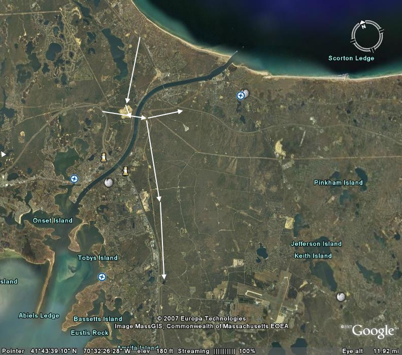
White arrows depict the overall highways configuration
March 22, 1997
Mr. William G. Smith, Editor
Cape Cod Times
319 Main St.
Hyannis, MA 02601
Dear Mr. Smith,
The recent letters to the editor concerning the concept of a third highway bridge to the Cape have been interesting, but haven’t touched upon an important aspect of marine transportation and the Cape Cod Canal.
The Canal needs a new bridge. One level for the highway and a lower level for rail service. Although the existing bridges have enjoyed over fifty years of careful maintenance by the Army Corps of Engineers, their usefulness has past. Canal passage is restricted to most modern containerships and roll-on, roll-off (Ro-Ro) vessels because of the low bridge height restrictions. Were new bridges constructed with vertical clearance meeting today’s height standards, perhaps 200 feet above high water, then the Canal could be dredged to its design depth of 40 feet below low water.
These improvements would then allow modern ships to save over one hundred miles of sailing distance between Boston and the ports to the south. This would contribute to the economic growth of New England ports such as Boston and Portland, Maine. Although concerns over larger ships using the Canal alert environmentalists, these ships are required to be navigated by trained pilots, and outer cape casualties such as the Argo Merchant or Royal Majesty might be avoided. Canal sight seers would truly benefit, as nothing slows traffic more on the scenic highway or Sandwich Road then a beautiful ship silently gliding through our unique waterway.
More on the benefits of the modernization of the Canal can be found in the Report of the Governor’s Commission on Port Development of 1994, the same report which sparked the creation of the Seaport Bond Bill and Commission.
Regards,
Thomas L. Bushy, CAPT MMA
Associate Professor of Marine Transportation
Massachusetts Maritime Academy
(508) 830-5000 x1952